See the photos here:
This was the longest trip yet. We spent seven days on the trail and took a ton of food. As always it took a bit of work dropping off a vehicle at the end and getting back to Kennedy Meadows. We hired Gary from Ridgecrest to take us to Kennedy. It took about 10 hours to pull it off and then we walked 11 miles. The weather was nice for the whole trip. I don't think it got much above 80 degrees. We passed and saw Beck and Monache Meadows. There was a controlled burn in this area that made the view a little murky. There never was a real clear day because of other fires. We are all carrying about 40lbs with food and bear canisters. It is the law up here and three extra pounds. I immediately felt the extra weight. I decided to bring my Mariposa Pack and it is overloaded. I took a chance with a light pack that turned out well. There is a lot of water up here. I think the farthest distance between water sources is seven miles and that is a miracle after 700 miles in Southern California. This is still cow country. We saw a big black object near the South Kern. Our eyes are old enough that for a while we thought it was a bear. Only a bovine. At the South Kern River we ran into a Sierra Club group that had bagged Olancha Peak. A guy came up to us in the dark and recommended we camp on the other side of the river. He thought we were part of his group and frankly he was a little nosy. After he found out we weren't with him he kept giving us advice. He turned me off. We were at 8000 or so feet and the stars were awesome. We got frost the next morning and our water bladders were frozen. It was a reminder to sleep with your water bottles. You can't filter water either with frozen tubes. Our first leg took us a long way up Cow Canyon. We filtered along the way: 14 hard miles today. We did see a lot of skunk cabbage. It was a bit hard to follow the trail in places because the whole area is so recently wet that every bush and plant is growing like a weed. There are still some wildflowers at higher altitudes which is a pleasure. We crossed Gomez Meadow on a causeway (a word I like to use) that keeps your feet out of the swampy meadow. A sheepherder carved a man smoking a pipe on a tree here about 100 years ago. I like ancient graffiti. We took a long to time to go the eight miles to pass the turn off for Olancha Peak and then down into Death Canyon. Our camp location that night was sensibly set by Bill before a 2000 foot climb that next day. I have developed a rash again on my lower back from the heavy pack. I think it is from the pack. I put duct tape on it and wrapped my fleece around my waist to stop its progress. The big climb on the 20th gave us a great view of Owens Valley to the east and the White Mountains. Perhaps we shall investigate them some day. We ran into Dave Drew recently retired from the Alaska DOT doing a section. Most of the hiking today followed a ridge that had several places to go off trail for water. I watched them all closely so we could get water at the last possible one, Dutch Meadow, to reduce water weight and then I missed it. We had to walk to Corpsman Creek to get water and we were thrilled when we saw it. We passed Trail Pass Trail. We needed a good camping spot and we found it at the edge of Poison Meadow which had a beautiful view east and west here.
On the 21st after Cottonwood Pass we passed Chicken Spring Lake. This beautiful lake with surrounding dramatic rocks called cirques marked the beginning of uniquely Sierran views. We had a big up after this and walked through a nasty section of rocks and sand. It slows you down and beats up your feet. There were some great views of mountains to the west. We passed a young couple. The women was pregnant and seemed to be far along. It couldn't be too long until a hiker baby was born. Another hiker, Bill, was starting his JMT trek from Cottonwood Pass. He was way overloaded and later we shared our water so he could survive to the next source. This day was the shortest. We slowly descended into Rock Creek, one beautiful place. We were alone when we arrived but soon there were 20 other hikers in the campground, a Sierra Club group, some older Boy Scouts with dads and a few strays. Bill, Ray and I were able to wash off very well in the river and even do some laundry. This has to be one of the more idyllic places we have ever been. One guy in the Sierra group figured out Bill's age and accomplishments and went on and on about how amazing he was. It made his day or week. It was nice to have some company to talk to. Saw our first Ranger who wanted to see our permits and bear canister. I showed her everything she needed while washing Ray's hair. She looked at the permit and said, "Where's Manning?" I explained it was the Canadian border. We attained Guyot Peak by 9:00AM the morning of the 22nd on the way to Crabtree Meadow. 3800 foot gain today which is the biggest of the hike. At 1:00PM today we met the John Muir Trail. The PCT and JMT join each other for 176 miles. It came after Crabtree Meadow which has a terrific view of the mountains to the east including Whitney. We had a big tiring climb up to the Bighorn Plateau that we were sure was badly routed. I renamed it "What's the Point" but it turned out to be the best way. Most of all our hiking has been at ten or eleven thousand feet, often above the tree line. The plateau has a 360 view of every mountain range within 50 miles. I saw my first Marmot. Our camp was at the crossing of Tyndale Creek which appears to run through blocks of rock stacked like Legos. I found a personal pool protected from the rushing water. It was wonderful. I almost got clean. We put our food in a Bear Box for the first time, a bear canister in a bear box, funny.
The next day we went over Forrester Pass after passing through a land of mystery and beauty. It was a something out of Tolkien. We passed creeks, ponds, grass, views of Whitney and patches of snow, some of which was watermelon snow, pink from algae. It reminded me of a Chinese contemplative garden. Now we have seen what they try to recreate in an urban setting. We met a very attractive lady, a Veterinarian from Canada, on the way up, obviously a veteran hiker. We took her picture and Bill and I were smitten. The trail over Forester Pass is a remarkable achievement. In places it seems to be carved out of the rock. Huge boulders everywhere. A nineteen year old died in 1930 when it was built and there is a plaque commemorating his death. We all felt very strong going up to the highest point on the PCT. There were at least eight hikers coming up the other way when we arrived. This turned into a flood of people we passed in the next few hours. Most of them loaded to the gills. I was worried that we had too much weight but almost everyone else had to be carrying ten to twenty pounds more. I felt sorry for them. I passed through a strip of snow covering the trail and the guys decided to walk around it on the talus. Bill said "you seem to be doing well" and then I fell on my butt. Soft landing and I was fine. Pride goeth
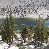
before the snow fall. There are lots of lakes here and many have a beaten path to them. I am sure the angling is good because we can see the fish hitting the surface. We descended into Vidette Meadows in a lovely treed area with Bubb's Creek nearby. We passed a lot of small streams and near the end of the meadow there were about six in a row which must be a record. We took a long break near the end of the day for a meal, washing and rest before climbing steeply out of the canyon. We saw a batch of lightly loaded hikers on the way up. There was a large pack train near the bottom and we deduced that they had been dropped off near the top to get the hiking experience. This climb was hard. We arrived about 7:00PM for our final camp near the junction of Kearsarge Pass and Charlotte Lake trails. We started the walk over Kearsarge early the next morning. It was Ray's 61st birthday. There are several lakes near and below the trail on both sides. Several feeder streams cross the trail. We never had to take off our shoes to ford a stream on this trip. The way out of a Sierra hike is a familiar one now with a sharp climb to a place in a rock wall and then down. There was good stream of hikers passing us on the way down. The first had a fishing pole and a Labrador. A Lab seems like the perfect trail dog and happy to be hiking. It is a long way down to the parking lot. We arrived about 11:00AM. I saw 154 hikers on this trip. The Sierras are pristine. People seem to be taking careful care in their travels. This was tough hiking. The views are becoming more beautiful and dramatic. It don't think, with snow pack, that we will be able to continue our journey for at least 10 or 11 months but we hope to get in some kind of trip in the meantime.
1 comment:
Did you have any trouble finding water along this section of the PCT (Kennedy Meadows to Mt. Whitney)? I am planning a trip on that section of the PCT and am curious. Thanks :)
Post a Comment