This section is 19.6 miles and nearly all downhill. As a matter of fact it goes from 7750 to 1360 feet above sea level. We passed the lowest point between this section and the Columbia Gorge on the Oregon Washington border. We camped the night before at the campsite after a 2 ½ hour ride with Ray’s son Jim up to the top. We are asking a lot of our relatives with this shuttling but it is working out. It was a warm and beautiful night. The sky was packed with stars. I slept badly. Don’t know why. The moon came up and I thought Ray had turned on his headlamp. We got off about 7:15 for our march to the bottom. The first thousand feet is covered with trees. We had fabulous views of the desert, mountains to the north, east and west. San Gorgonio looms bare and forbidding ahead. The next section is listed as difficult. We will take it slow and easy. There was a fire here in July and the vast majority of the hike down is scorched desert scrub. We have spent so much time walking in burn areas I think our little group should be called the “Fire Walkers.” The fire turned the mountain into a dirt slide. Most of the trail is covered with soft soil that has slipped over it and, in places, made it appear just like the rest of the slope. We saw lots of prints from deer. They seem to think staying on the trail is a good idea too. We believe we saw the paw prints of a mountain lion. Bill said that the way to tell the difference between those of a dog is that the nails don’t show and they didn’t. This section is a very long series of switchbacks through boulder strewn hills and canyons. Most people have bitched about the length of the trip. We decided in advance that “it is just the way it is” so we didn’t worry about it. It helps to have an attitude check to keep your spirits up. We passed though another giant boulder area. Some of them are 30 feet tall. We went under some giant rocks that looked like they were about to fall anytime. This was the perfect time for Ray to reminisce about a bridge project where several people were flattened under a boulder so large they didn’t bother to dig them out. They just put a memorial on top, lovely. Snow Creek Village is a small group of varied structures on the desert floor below and we finally saw it about 2:00PM. The end of the trail is in view most of the day. I suppose that is why people get tired of this section. We have hiked this distance before and have never seen the end until the last few minutes. The end of Snow Creek has a water district that serves Palm Springs. The miracle is that they have put a water fountain, with cold water; at the point the trail hits the desert floor. It was wonderful. We drank, filled out bottles, and poured it on our heads. The weather was nice on the way down but now it was hot. We had to walk across the desert floor and it was 95 degrees. It didn’t take long to drag us down. Of course we have already walked 16 plus miles. I have a tendency to keep on slogging regardless of how I feel. I should listen to my body. I noticed Bill flagging so we took a couple of breaks. The strange part about this area is a series of 4 X 4 posts marking the trail to keep the shifting sand from obscuring it. Closing in on the freeway I had spoken to my daughter Janessa and she was waiting on the other side. A fire broke out near the Exit and I called her and said “are you all right?” She said, “I’m fine, I see the fire. Should I go and look at it?” I said no and she said “you’re no fun.” It turned out a mobile home had gone up in flames but it gave us a start. We passed under the railroad and freeway and we were happy to finish, a great trip.
Thursday, October 14, 2004
Sunday, August 01, 2004


Fobes Saddle to Fuller Remote Campsite
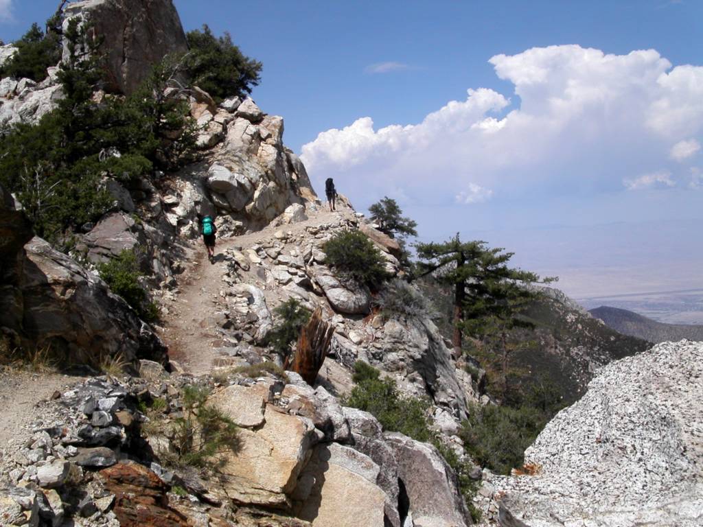
Fobes Saddle to Fuller Ridge Remote Campsite July 25th, 2004
The first morning, we didn’t start at the Fobes Saddle spur trail till after eight and got to the PCT at the Saddle just after nine. The early starts are getting harder the farther north we go. We found a six gallon cache here courtesy of Bill’s Trail Kitchen. The trail gets steep immediately. We passed Spitler peak on the way to Apache peak.
Bill stopped to fix a hot spot on his foot. I have never had a problem with my New Balance trail runners, but they slip too easily. I have fallen for the ultra light mantra about using these shoes instead of boots. I think without hiking poles I would have hurt myself. I have a new pair, and if they don’t improve my stability I am looking for another shoe.
It was already about 85 degrees here with a fair wind. Very few wildflowers at this time of year, but we did see some Red Penstemon, Indian Paintbrush, and a very cool plant with a red cone and purple flowers. When the pictures come back we have to identify it.
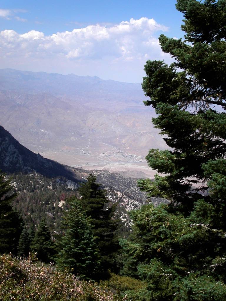
We lunched at about 1:00 after Apache peak, and were already wiped out. Ray said, “When I feel like this I am ready to stop.” I got a headache from the altitude but Advil, food, and a break made me feel like a new man. You can see the Coachella Valley all along this part of the trail.
Near Antsell Rock, we ran into a shirtless man with a British accent walking the other direction who said he was from the Zen Mountain Center. We don’t know where he entered the trail. We ran into gnats that flew around our faces like a mask of bugs. I inhaled one in my nose and it came out my mouth. Ray ate one and said, “Good protein!” The trail is carved out of solid rock in many places here and must have been a Herculean task to build. This section is dangerous in the winter with snow. We are glad to be walking it in dry conditions. Red Tahquitz Peak is literally red, and we had to round it on the east side to enter the forest beyond.
The wilderness up here is a patchwork of National Forest and Mount San Jacinto State Park. We entered the Eden that is the top of Mount San Jacinto. It looks like a punchbowl surrounded by peaks. At first glance you might think it is a dormant volcano. It is filled with trees, and has a big green meadow, Skunk Cabbage Meadow, near the bottom northeast side. Unfortunately up here the bark beetle infestation is in full force, and a good twenty percent of the trees are dead or dying. Only several years of average or better rainfall will solve the problem. It is still quite beautiful.
The grade went down into the valley and it was a welcome breather. Our permit was for Strawberry Junction Campground, and it was still 7 miles away. Just before the trail meets a 1/3 mile cutoff to water in Tahquitz Meadow, we came across good flowing Tahquitz Creek. This stream, which surprised us, came from Tahquitz Peak above, and since all the snow is gone Bill and Ray surmised that it originated from ground water. It was a lot of water. We filtered about 10 liters of good, cold water between us. We decided any pauper can have water down the mountain, but on the mountain the man with water is King! I drank six liters today! We saw a mule deer and heard some doves. We were exhausted and no where near our goal.
We arrived at Saddle Junction to see a very tired man about 30 years old sitting on a tree stump. “I used to hike all the time, and this is first time I’ve been out in two years,” he said. Apparently, the 2-1/2 mile Devil’s Slide Trail had been more than enough for him. We finally decided to camp north of Saddle Junction on a sandy area overlooking Idyllwild and Hemet beyond. We had covered nine miles. It was impossible to get to Strawberry Junction, where we had arranged for the camping permit, from Fobes Saddle in a day of hiking, but that was the only permit area available to us. We felt bad about it, but it was getting dark. We all agreed to tell the truth if we ran into a Ranger. We didn’t have a choice. I understand why they restrict camping: People have damaged the area in the past. We treaded lightly. I was stunned to realize that I had left my new stove at home. Ray shared his cooking gear with me, and I enjoyed Red Beans and Rice. I added tuna to both our dishes. Bill had lent me a tent because my Tarptent had not arrived in time. Unfortunately, he brought the wrong poles, but my hiking poles crossed and adjusted did the trick, and I had a tent. It was a warm night, and with a half-moon everything was quite clear.
We heard some people whooping as they descending the trail to Humber Park. It became obvious we were probably the only people on the whole mountain; a strange but powerful feeling, especially with millions below in our view. I did not fall asleep till 1:00AM, but lay there for nine hours. I don’t know why; perhaps I was too tired. I heard Ray rustling at 5:30 and woke up. Bill had blisters on both heels. He treated them and we were on our way by 7:00AM. We climbed another 900 feet in the next few miles. We were over 9000 feet, a record so far. It was cooler than the day before. It took my body a while to wake up.
Strawberry Cienega was a revelation. It was really a seep. It takes only a little water to change the flora dramatically. All the plants are different and lush for over a hundred feet on each side, with Ferns, Bracken and Skunk Cabbage (which Bill says works well as toilet paper, although I’ll take his word for it). As usual, Bill took a lot of great pictures. We got to Strawberry Junction and stopped for a snack. There are some giant boulders beyond here with large, pock-marked faces. People have decorated the holes with pine cones. Bill said he had learned that these “soft spots” form when different kinds of molten rocks come together in a lava flow, and later erode more quickly leaving the pocks. We shall call them “Devil’s Marbles”. We saw and smelled some beautiful Wild Azaleas. We soon crossed a creek. It wasn’t much, but we could dip Ray’s cook pot in to fill his bucket for filtering. We loaded up.
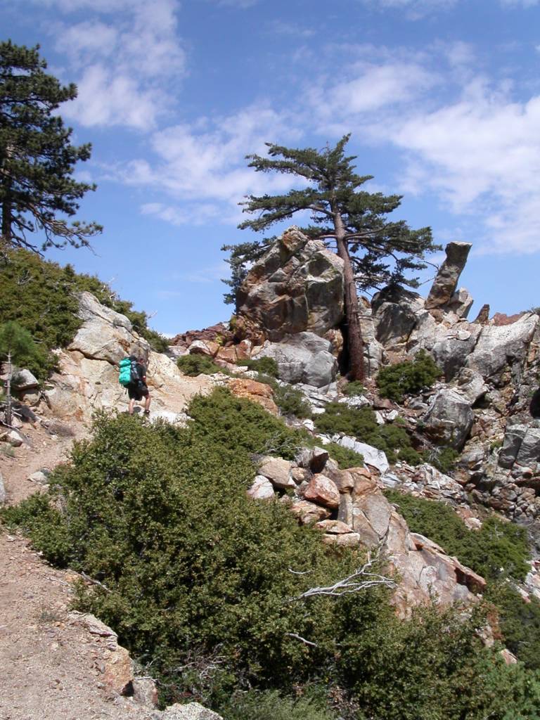
We had much more shade today and the walk was easier. After we took the Fuller Ridge turn-off, we came across a whopper of a creek. It turns out this was the north fork of the San Jacinto River and boy was it running well! We didn’t need water ,but we marveled at it for a few minutes. Fuller Ridge, like the San Felipe Hill before it, has made us nervous. We thought it was sun baked; lacking shade. That is not true. It is well shaded, but it is perilous at times. It is mostly rock, and during the winter I am sure it is dangerous. I slid about some and found the trail hard to follow at times for the lack of soil. A little snow and you could get lost. The grade was mostly downhill, but the steep incline up to Castle Rocks is short but hard. We could see the San Jacinto Peak from here, and also the burned trail area down to Highway 10. It is really something and worth the walk. We met our third and final person on the way to Fuller Ridge Remote Campsite. He was sunburned, without a hat, and carrying a backpack with the tag still on it. His name was Gerald, and he seemed a bit addled. He was heading for an overnight up the trail. I realized he was mumbling something about us not having a ride at the campsite, and this being a bit late in the season for through hikers. Actually I think he was fine but I was confused. We found his motorcycle at the campsite. Past the campground we passed Black Mountain Truck Trail, and found the barricaded final section to Highway 10. We will go as soon as it opens. We walked down to Black Mountain Campground and were picked up by my daughter, Janessa, and her friend Christie soon after. A great, hard and beautiful trip.
The first morning, we didn’t start at the Fobes Saddle spur trail till after eight and got to the PCT at the Saddle just after nine. The early starts are getting harder the farther north we go. We found a six gallon cache here courtesy of Bill’s Trail Kitchen. The trail gets steep immediately. We passed Spitler peak on the way to Apache peak.
Bill stopped to fix a hot spot on his foot. I have never had a problem with my New Balance trail runners, but they slip too easily. I have fallen for the ultra light mantra about using these shoes instead of boots. I think without hiking poles I would have hurt myself. I have a new pair, and if they don’t improve my stability I am looking for another shoe.
It was already about 85 degrees here with a fair wind. Very few wildflowers at this time of year, but we did see some Red Penstemon, Indian Paintbrush, and a very cool plant with a red cone and purple flowers. When the pictures come back we have to identify it.
We lunched at about 1:00 after Apache peak, and were already wiped out. Ray said, “When I feel like this I am ready to stop.” I got a headache from the altitude but Advil, food, and a break made me feel like a new man. You can see the Coachella Valley all along this part of the trail.
Near Antsell Rock, we ran into a shirtless man with a British accent walking the other direction who said he was from the Zen Mountain Center. We don’t know where he entered the trail. We ran into gnats that flew around our faces like a mask of bugs. I inhaled one in my nose and it came out my mouth. Ray ate one and said, “Good protein!” The trail is carved out of solid rock in many places here and must have been a Herculean task to build. This section is dangerous in the winter with snow. We are glad to be walking it in dry conditions. Red Tahquitz Peak is literally red, and we had to round it on the east side to enter the forest beyond.
The wilderness up here is a patchwork of National Forest and Mount San Jacinto State Park. We entered the Eden that is the top of Mount San Jacinto. It looks like a punchbowl surrounded by peaks. At first glance you might think it is a dormant volcano. It is filled with trees, and has a big green meadow, Skunk Cabbage Meadow, near the bottom northeast side. Unfortunately up here the bark beetle infestation is in full force, and a good twenty percent of the trees are dead or dying. Only several years of average or better rainfall will solve the problem. It is still quite beautiful.
The grade went down into the valley and it was a welcome breather. Our permit was for Strawberry Junction Campground, and it was still 7 miles away. Just before the trail meets a 1/3 mile cutoff to water in Tahquitz Meadow, we came across good flowing Tahquitz Creek. This stream, which surprised us, came from Tahquitz Peak above, and since all the snow is gone Bill and Ray surmised that it originated from ground water. It was a lot of water. We filtered about 10 liters of good, cold water between us. We decided any pauper can have water down the mountain, but on the mountain the man with water is King! I drank six liters today! We saw a mule deer and heard some doves. We were exhausted and no where near our goal.
We arrived at Saddle Junction to see a very tired man about 30 years old sitting on a tree stump. “I used to hike all the time, and this is first time I’ve been out in two years,” he said. Apparently, the 2-1/2 mile Devil’s Slide Trail had been more than enough for him. We finally decided to camp north of Saddle Junction on a sandy area overlooking Idyllwild and Hemet beyond. We had covered nine miles. It was impossible to get to Strawberry Junction, where we had arranged for the camping permit, from Fobes Saddle in a day of hiking, but that was the only permit area available to us. We felt bad about it, but it was getting dark. We all agreed to tell the truth if we ran into a Ranger. We didn’t have a choice. I understand why they restrict camping: People have damaged the area in the past. We treaded lightly. I was stunned to realize that I had left my new stove at home. Ray shared his cooking gear with me, and I enjoyed Red Beans and Rice. I added tuna to both our dishes. Bill had lent me a tent because my Tarptent had not arrived in time. Unfortunately, he brought the wrong poles, but my hiking poles crossed and adjusted did the trick, and I had a tent. It was a warm night, and with a half-moon everything was quite clear.
We heard some people whooping as they descending the trail to Humber Park. It became obvious we were probably the only people on the whole mountain; a strange but powerful feeling, especially with millions below in our view. I did not fall asleep till 1:00AM, but lay there for nine hours. I don’t know why; perhaps I was too tired. I heard Ray rustling at 5:30 and woke up. Bill had blisters on both heels. He treated them and we were on our way by 7:00AM. We climbed another 900 feet in the next few miles. We were over 9000 feet, a record so far. It was cooler than the day before. It took my body a while to wake up.
Strawberry Cienega was a revelation. It was really a seep. It takes only a little water to change the flora dramatically. All the plants are different and lush for over a hundred feet on each side, with Ferns, Bracken and Skunk Cabbage (which Bill says works well as toilet paper, although I’ll take his word for it). As usual, Bill took a lot of great pictures. We got to Strawberry Junction and stopped for a snack. There are some giant boulders beyond here with large, pock-marked faces. People have decorated the holes with pine cones. Bill said he had learned that these “soft spots” form when different kinds of molten rocks come together in a lava flow, and later erode more quickly leaving the pocks. We shall call them “Devil’s Marbles”. We saw and smelled some beautiful Wild Azaleas. We soon crossed a creek. It wasn’t much, but we could dip Ray’s cook pot in to fill his bucket for filtering. We loaded up.
We had much more shade today and the walk was easier. After we took the Fuller Ridge turn-off, we came across a whopper of a creek. It turns out this was the north fork of the San Jacinto River and boy was it running well! We didn’t need water ,but we marveled at it for a few minutes. Fuller Ridge, like the San Felipe Hill before it, has made us nervous. We thought it was sun baked; lacking shade. That is not true. It is well shaded, but it is perilous at times. It is mostly rock, and during the winter I am sure it is dangerous. I slid about some and found the trail hard to follow at times for the lack of soil. A little snow and you could get lost. The grade was mostly downhill, but the steep incline up to Castle Rocks is short but hard. We could see the San Jacinto Peak from here, and also the burned trail area down to Highway 10. It is really something and worth the walk. We met our third and final person on the way to Fuller Ridge Remote Campsite. He was sunburned, without a hat, and carrying a backpack with the tag still on it. His name was Gerald, and he seemed a bit addled. He was heading for an overnight up the trail. I realized he was mumbling something about us not having a ride at the campsite, and this being a bit late in the season for through hikers. Actually I think he was fine but I was confused. We found his motorcycle at the campsite. Past the campground we passed Black Mountain Truck Trail, and found the barricaded final section to Highway 10. We will go as soon as it opens. We walked down to Black Mountain Campground and were picked up by my daughter, Janessa, and her friend Christie soon after. A great, hard and beautiful trip.


Monday, June 07, 2004

Thursday, June 03, 2004

Tuesday, June 01, 2004

Monday, May 31, 2004
Highway 74 to Fobes Saddle - May 25, 2004
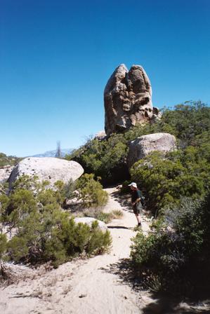
Jim Garrish, an acquaintance of Ray Ellis, joined us today. He was a good companion. Parking the pickup vehicle took a little off roading so we got off late. This segment is the first in the San Jacinto Wilderness, about 16 miles. It was pretty and varied. There were no big inclines but a gentle slope most of the way. The trail runs near and crosses Penrod creek on towards the Desert Divide. That is literally what it is; a ridge separating the mountains and the Coachella Valley to the east. We had a good view of Indio, Palm Desert and the Little San Bernardino Mountains. The Pacific Crest Trail lived up to its name again. The trail runs north along this ridge with a great view almost everywhere. Little patches of blackened pines started to appear. I had read that a fire burned here 25 years ago but the only obvious damage is to the conifers. One of the saddles was a beautiful meadow. Like a football field with a mountain view. I saw another Velvet Ant. This amazing bug (really a flightless female wasp ) is quite pretty. We passed Pyramid Peak and it lived up to its name, quite geometric. We saw four deer. We crossed Little Desert peak and the vegetation became quite sparse. Most of the area is covered with chaparral but finally we got into some nice groups of trees. We were well over 6000 feet in altitude. There are many springs in striking distance of the trail. With a little effort water is available. Our next segment is 44 miles and water is the big issue. Signs that say “Trail” made me say “isn’t that a little obvious” but Ray reminded me that they are helpful when there is snow up there. I righted one that was knocked over. There are some pretty lakes to the west in the valleys. One small, bright blue one, is near Morris Road and the other farther west is Lake Hemet which is quite large. Palm View Peak brings the trail over 7000 feet and all of us noticed some breathlessness that can only be attributed to altitude. This area opens up into wide plateaus of meadows and trees. Nice camping spots but windy. Northeast of here we could see our truck quite close below but the trail must take a big switchback to descend to meet Fobes Saddle on the eastern side. . This must be the deepest saddle on the trail so far. We lost more than a thousand feet. I was worried the Fobes Saddle trail would be hard to find but it is very well marked. The dramatic incline across the saddle to Spitler Peak looks like a serious mountain. We will have to crank up our workout. A great day.
Warner Springs to Highway 74 April 26 to April 28th, 2004
This was our longest hike to date. The segment is a little over 42 miles. We cached 7 gallons of water at two locations. It wasn’t enough as you shall see. Bill Redman and I had ticked off the elbow between Highway 79 SW and 79 NW the previous Monday. It is a beautiful two mile section with rolling hills, meadows and at the north end a deserted, overgrown, oak covered private campground with space for RV’s and clean stocked port a potties! We saw miner’s lettuce in the shade which is the only edible thing I know about on the PCT. The trail passes under the NW 79 and into Agua Caliente Creek. A little water turned into a good stream in a few miles where met some young ladies coming back from an overnight in the canyon. The trail is good but overgrown in places. A steady climb brought us to an overlook of most of Warner Springs and Ward Canyon to the west. Soon we were in the burn area. Sadly the few conifer trees that dot the charred chaparral are gone for good. We passed our first through hiker Cecily P. from Michigan. She was moving slowly and struggling on a grade. We asked her if she needed anything. She said she was fine and would learn later how fine she was. We set a big goal for the first day. I wanted to get to our cache at Chihuahua Road and maybe to Combs Peak. It was all burnt and the dust sandblasted our legs. Gaiters don’t work to well with this type of soil. We saw and photographed a gopher snake and some horny toads. It was murky day so the view wasn’t too hot. Frankly it isn’t very pretty out there. There are some signs of spring and beautiful pink flowers on the beaver tail cactus where the fire hasn’t done them in. There are a lot of weeds in the burn areas much more than in the unaffected parts. When there is no chaparral weeds appear to have no known predators. I would like to know the reason for this. We had a long slog and made it to our cache of 4 gallons for the three of us. The big cache of maybe 50 gallons is about half gone. Kudos to Jack’s Painting Crew of Escondido for the support. I took his card. There must be something that needs painting. After a break we moved on to Combs peak for our camp. It is a good grade up there but less than two miles. The good camping area is on a shelf east of the peak. It has a good view east of Terwilliger and Anza below and our next goal Mount San Jacinto. Today’s mileage 17.5. Ray Ellis our other hiker (AT 96) was hurting. Some days we feel it more. We got off by 7:30 the next morning but not before Cecily from Wisconsin came ambling by. She said Hi and took a water break while we chatted. We started to be impressed by her. Her actions spoke louder than her words. We passed her soon as we took the long descent east of Terwilliger Valley. We finally passed out of the burn zone. The big moment for Bill Redman and I was seeing the tiny wooden “County Line” marker. We had walked every step from the Mexican border and passed our first small goal. It got hot. April 27 was the freak hot day. It got up to 95 by time we got to Tule Canyon Creek Trail. The PCT has less signage here. It is marked as the California Riding and Hiking Trail. We took a break under some Manzanita and soon heard a voice. Dusan from Chicago in his late 20’s, strapping and swift. He found out about the PCT two months ago and decided to do it. A substitute teacher fit but with no technical clothing except the de rigueur New Balance and an old heavy pack. We talked a bit and expected to be passed by him soon. He took a sensible midday nap. We arrived in Nance Canyon about 3:00PM and called it a day. We met a shy couple there from Colorado resting under a tarp and reading the Pacific Crest Trial book. Everybody on the trail has the book or a portion of it. They were pushing on to Table Top/ Terwilliger Road after the heat of the day. We took the big sandbar on the south side of the dry creek for a campsite. It was hot and windless. Gill, 67, from Victoria B.C. walked by. I said hello and he asked “why would anybody live out here?” I tried to explain but gave up. I couldn’t think of a reason. Soon after Cecily P. from Michigan plodded by. “I want to get to the top tonight.” I was beginning to believe everything she said. Silently I gave her the trail name “tortoise.” I set up my tent, a Six Moon Designs I am borrowing from Glen Van Peski (check out his website), and left the front net open. When I crawled inside later there were at least a hundred flies, mosquitoes, bees and tiny things buzzing around inside the back end. I crawled in on my back and killed them one by one with toilet paper. Ray Ellis just laid out his mat and bag and took a nap. It was so hot that day that we were cooking dinner at 4:00PM! I got up later to do you know what and heard a big crunch in the brush. Bill gave me his headlamp so the giant creature could see me better. There was lots of noise through the night including some cute squeaking. We had decided on an early start. I woke up at 3:50AM to Ray saying “are you awake.” I woke up and he went to sleep again. We got off by 6:10AM. It could have been hot again and we were low on water. Water is the most precious thing on the trail especially here in Southern California. We got out of Nance canyon easily. We got to Hiker’s Oasis and were thrilled to see a huge bookshelf of water. We ran into Damien a divorce attorney from Hayward. He was headed to I-10 this year and returning to the San Gabriel’s the next. He said he wanted to quit every day from the border but he was better now. He also said the Cicely P. had left an hour before. Not a big surprise. We crossed the Table Mountain and descended into Alkali Wash. It is a mini Hauser Canyon in looks but much easier to pass through. The following trail on the narrow edge of the Horse Canyon is remarkable. The slip fault shows the result of portions of the mountains slipping off into the canyon in the last ten thousand years. We followed a gentle grade on the south side of Lookout Mountain to a low gap and relieving view of Highway 74 and the San Jacinto’s ahead. We just passed Cecily P. before Highway 74 but I am sure she would have beaten us to Canada by a month. We found out she was an AT veteran (2000). It was a great trip. I can’t wait for the walk to Highway 10.
Scissors Crossing to Warner Springs January 22nd to January 24th.
Our party included Bill Redman, Ray Ellis (AT 98) and me, Dana Law. The weather was terrible but we took one step at a time. It wasn’t raining when we got to Scissors Crossing. We spent the night to get an early start. We were off by 7:20AM. Slow walk up Grapevine Mountain with heavy packs. There are some pretty cacti and cool Juniper trees on the way up. We found a rain induced rockslide about a mile along with minor damage to the trail. Vulcan Mountain to the west was snow capped with a heavy cloud cover. A light shower kept us out of our rain gear. I had packed 2 ½ gallons of water in preparation for the “dry” San Felipe Hills and probably in the first time in years it was unnecessary. Ran into Jeremiah from Tennessee, “doing the bottom half” who had passed through snow in the Laguna’s. “I filled up my cookware with rain overnight on Granite Mountain”. We finally needed our raingear late in the afternoon and then camped at 4100 feet overlooking the San Felipe valley in a big wind. It was a poor camp but we were spent. Military helicopters passed north through the valley at 2000 feet, maybe lower. It was 37 degrees overnight. Our party got off at about 7:15AM with a quick trip into the clouds and through the “Gap” that we didn’t see but felt as the trail descended. This is the burn area and there isn’t much left. We made an early arrival into Barrel Springs about 10:30AM. There has been quite a bit of trail work on the last mile or two of the trail. The water trough is full and running. We crossed S-22 after an early lunch and headed across the beautiful meadows. Saw cow pies but no cows. The trail is distinct here and picturesque. It was cold and blustery but no rain today. San Ysidro creek is running but easy to cross. Walked to Canada Verde. The creek here is running well and is lined with beautiful oaks. We ended our hike at the Warner Springs Fire Station which has a patio, chairs, water and log book just for PCT hikers! The last eight miles of this trip was a pleasure after the dreaded “Hills.” We can’t wait to head to Highway 74.
Pedro Fages Monument to Scissors Crossing January 12th, 2004.Day 6 We had a big break in our hike because Bill Redman had a heart attack. He had surgery to implant a stent in the afflicted artery and we took four months off for important recovery. We started at the monument so we could park our cars after picking up our terminus driver at Scissors. This spur is about one mile southwest from the PCT. Joyce, Lou and Ray Ellis joined us for 7:00AM start. It was 39 degrees. My new Land’s End Marinac wind stopping fleece jacket kept me very warm but my face and ears stung. It quickly warmed up at the escarpment over looking Oriflamme canyon and Granite Mountain. We took a group shot and went down the jarring rutted decent to Chariot Canyon Wash. There was evidence of a huge amount of runoff from the recent rain but no running water only wet sand. The trail goes up the hill and turns left along Chariot Mountain to the Rodriquez Canyon. We could see an airstrip in the desert floor to the southeast that I learned later was a private strip called Rancho Vallecitos. Rodriquez Canyon is a pleasant area between two mountains. When we hike we see places where people could live a secret life and rarely be seen by outsiders. Cut off from the rest of the world. The view here is quite nice and we had an early lunch with a view of Banner Grade and Valle de San Felipe. Lou found a rock which I have that is imbedded with black tourmaline. He has quite a knowledge of plants and rocks. We passed some old mines as we entered the fringes of Granite Mountain. The mountain is quite steep in places and I watched my step. There was some damage to the trail from runoff and dirt slides and we had to mountain goat a little. There are plenty of rocks to slip on as well. Joyce who is terrific shape twisted her ankle a little and suffered from hot spots. Lou brought some moleskin and cut some for her relief. I have added it to my hiking list. Bill took a fall too and it looked scary but wasn’t. I didn’t fall but slid about a half dozen times like a drunken sailor. The trail goes around the north side of Granite Mountain for a long way. The guide book says that a direct route wasn’t possible because of property rights. When it is hot it must be hell here. We saw more and more succulents such as Beaver Tail cactus, Teddy Bear Cholla and Agaves. We saw and photographed what may have been a mortar (Metate) that the Indians ground Agave in past centuries. We imagined a person sitting, grinding with a protective view of the valley below. Lou pointed out a Juniper Bush which I have seen but had no name for. We stopped on a rocky outcropping to take a long break. The next segments along San Felipe Hills are clearly in view. Water will be the big challenge for the two days necessary to reach S-22 at Barrel Springs. Ray has been on all of this section before and it helped to have his knowledge. He is a quiet giant in my view. Humble but very accomplished. Bill has plotted all of our waypoints for this trip and they were spot on. He is going to teach me the Topo program we follow and print maps from. We took a sharp right at base of Granite Mountain and went along a fence line to S-2 and then down it nearly to the crossing. Bill, Ray and I jumped over a running San Felipe Creek successfully but I got wet when I went back to fetch my sunglasses. We were a bit stiff and tired but all in all a great day.
September 5, 2003 Day 5. I decided to do this last small segment (about 5 miles) with Bill Redman because it would make the trip to Scissors Crossing more manageable. Bill thought we should do a turn around and just park at Lucky 5 Gate. It was a pleasant morning. San Diego was burning up but the mountains were delightful. This is not an alpine area. More of it is open, rocky and burned. Still it has its own beauty. Once again the Anza Borrego opens up to the east and today it was quite clear with the Salton Sea visible in the distance. The trail is open, clear and serpentine here. There are many signs of flooding in the remarkably short washes. It is a reminder of how quickly these things can fill up with water. Because of the burns the rock outcroppings become more visible. One of them looks as if some mason erected a wall for no reason. I have seen this before on the way to Hellhole canyon and isn’t nature a wonder. We ran into a rattler. I think this is our 3rd we have seen and the fourth we have heard. They like the trail as much as we do. We woke up the last one but this one was wide awake. It is the one dangers of hiking that bothers me a lot. I suppose we are more in danger of breaking a leg but the thing about snakes is that they are easy to miss until you are right on them. I don’t want to hike alone for this reason. The trail follows State One for quite a while and veers off to continue on the escarpment to meet the Mason Truck Trail. We lunched on the concrete water tank overlooking the descent into Rodriquez Canyon, around Granite Mountain and into Scissors Crossing. We will be going early in October or as soon as the desert cools off. Maybe you can join us.
Burnt Rancheria to Lucky 5 Ranch August 15th, 2003
We were very worried that if we didn’t get an early start we would suffer greatly from the heat. It has been 100 degrees here in El Cajon for over a week. Kristin decided not to go because of the worry that she would “melt.” It turns out that this walk was in the coolest part of the county. It got in the low eighties but the first third of the trip was a cool overcast day with a little mugginess. It was good to be back on the trail. We did 17 miles more or less and most of it on the Laguna Escarpment overlooking the Anza Borrego. The desert air was pretty murky. The beginning of the trip is pines and oaks. These areas are peaceful and pleasant. I took some of those ubiquitous pictures of glades that always intrigue me. Soon we are in the brush that is so common in San Diego. It was surprising to still see some flowers at this late date. Many of them, a tiny purple one, on a dead plant, probably dried at its peak. We passed the radar domes on Stephenson Peak. Bill Redman took some pictures of me and Robb Latimer, our new and weird hiker, with the domes in the background. The miracle of this area is the forest east of the trail and the shrubs to the west. This climate from the cool ocean air with moisture and the dry desert air is fascinating. I have finally “got it” how dramatic and important these zones are. Certain flora doesn’t’ grow everywhere and while environmentalists are a lot of trouble they are right that we have to protect certain plants because of their limited life zones. The trail is also the “Desert View Trail.” The trail becomes a shrub and brush route as the forest recedes. The 2002 fire turned the area into a wild plant paradise. We saw a white penstemon which looks like a weed with great white flowers and a sage and many others I don’t know. It is nice to have the shrubs gone for a while. It opens up the view of the desert. The new growth is an example of the good side of fire. It is a remarkable comeback. At Pioneer Mail the trail turns right to the old roadbed for S-1 that cuts through the rock of a cliff overlooking the desert. It is a neat place with brown friable metamorphic dramatic rocks and old concrete bridges. Near the end is a monument to three people who died launching themselves off in hand gliders into Vallecito Valley. I will take hiking. This place is at the end of Kwaaymii Point Road which reconnects to the new S-1. The trail moves away from the road west of Garnet Mountain and continues through the beginning of Oriflamme Canyon. Donna had gotten a hold of me earlier and warned of a thunderstorm coming in. We saw the result of a recent storm in the washes and it made us a little nervous to see thunderheads in the south. They were plenty far away though. Near the end of the trail a water cache in a shelf like box is set up. Robb was about to pour some on his head when I stopped him and said “We shouldn’t use that. It is for people in need.” He talked too much, asked too many questions and makes me look like a quiet person. I don’t want him on the next hike but will ask Bill’s permission to exclude him.
June 20th, 2003 Boulder Oaks Campground to Burnt Rancheria Campground
I have to make these trips when I am off, when my friends are available and hopefully when the weather is nice. Luckily today was the perfect day. Bill Redman and Kristen Greenaway joined me. Kristen’s Uncle Bob from Canada came along too. Our June gloom seems particularly long this year. It was raining in El Cajon in the morning. When we got to Boulder Oaks it was still overcast but clear when we dropped off the second vehicle at Burnt Rancheria. The trail goes under the highway eight underpass. For me this was a Rubicon. Dreaming of this trip I kept wondering where it passed it and it seemed, even though we have gone a tiny amount of the way, a big deal. Maybe it meant I was serious about doing this trail. There was a bit of water in Kitchen Creek. There are some interesting rocks there. The Buckman Springs Valley is very pretty and we got some shots. We are fortunate to be hiking in June. There are many flowers and color. This stretch wouldn’t be much out of the wet season. It would be very brown and cheerless. I am glad we didn’t do it when it was hot. We kept hearing something vaguely like a rattlesnake. It made me jump several times. Kristen thinks it was clusters of cicadas. I think she is right. Several flew by me on the trail. I have never heard more than one of two together. There was a lot of Scarlet Bugler. It often lines the trail so you can see where it goes ahead. We can’t figure out why it is just on the trail, planted? My favorite flower along the whole trail I have now identified as the Golden Bowl Mariposa , yellow with brown speckles inside. I thought it was a poppy. Uncle Bob kept running ahead of us for some reason. I think of hiking as a communal activity, a chance to get to know each other and talk, to share the trail. It is not the way everybody feels though. I don’t know why he kept running off, more about that later. We took an early lunch at the crossing of Fred Canyon Road. As we left this area we gained quite a bit of altitude quickly. Cibbets Flat was below us and looked like a great oak shrouded campground. Kristen brought along her dog Oscar is a strong trail dog. He would run ahead of us, find shade to stand in, and the run ahead again when we caught up with him, smart dog. Kristen has a special collapsible bowl and he drank about a liter and a half. I like quartz and there is quite a bit strewn along the trail, big pieces too. It seems some one threw them out like bird seed. One of the landmarks on this section of the trail is Long Canyon. There are a lot of long canyons along the way and I said, too early, is that Long Canyon? It wasn’t. I asked several times and it became a joke. We finally got there. Once again proving I don’t usually know where we at and can’t imagine what it will look like till we get there. It branched out to the right, wasn’t very wide but quite beautiful. We saw our first Wild Roses which at one point filled the canyon as giant shrubs but grow smaller too. I think they are properly called California Roses. Long canyon has a mix of oaks and pines. These were the first pines on the trail. Uncle Bob had disappeared again when we sat down for another meal and rest. Kristen said it is good we don’t have big egos. I had no desire to keep up with him but I was beginning to worry. We sat in the shade of an oak. There was a little water in the canyon, enough for a hiker to safely filter for use. Kristen saw some bees and said that is how she knows that the water is drinkable. I wonder if that is true. We saw a pair of jeans and shirt discarded on the trial and a jacket. It is spooky. I didn’t know how far the illegals get on the trail and can’t figure out why they leave clothes. We saw a few shiny, prickly, holly like bushes and a long brown lady finger on the trail I can’t identify. We saw several hummingbirds. I wondered where they go when there are no flowers. We walked out of the canyon in some switchbacks and passed near several pretty meadows. Climates are so fascinating. There are oaks and pines in the canyons but further up it are chaparral and the occasional open meadow with grass and trees. I look forward to understanding how this works. I had a brief panic attack worrying about Uncle Bob. We hadn’t seen him since way before Long Canyon and we worried he wouldn’t know where to turn off the trail to get to the car. I decided to stop worrying and quicken my pace. I was a little angry with him. He should have stayed with us and I should have said something when I understood his personality. We got into the pines which smelled good. A few dead trees apparently the victim of the bark beetle. We had started to track Uncle Bob’s tread which included a big “N” and saw horse tracks as well. A one point he marked the trail with an arrow and the word “Bob”. It pissed me off. The trail notes said the ground was covered in “Duff” which turned out to be dead leave and branches. When we got to the turn off for Burnt Rancheria we made a big deal of looking for Uncle Bob’s spoor and saw that he found it. I said to Bill and Kristen “I bet he says, Where have you been?” and we found him by a park bench and he said “Where have you been?” what a prick. I didn’t talk to him for quite a while. I restrained myself from lambasting him and now I wish I had. Still it was a good trip and we all enjoyed it.
Hauser Canyon to Boulder Oaks Campground June 10, 2003
It was a June Gloom day in El Cajon when we left and beautiful, clear and 60 degrees when we arrived at the trailhead. Bill Redman and I walked back to Hauser Canyon from Lake Morena so he could get the steps that he missed because of the emergency pickup. It is an easy trail over the hills to the canyon. We took some pictures of trees he thinks are Junipers. The trip down and back was easier for me because of the lower temperatures. We walked to the helicopters landing spot. I don’t like retracing steps but it had to be done. It may be nuts but we have to do it. I want to say I walked the whole trail someday and so does Bill. We saw the most amazing bug with three fuzzy almost fluorescent segments about 6 tenths of an inch long with a narrow black band between the second and third segment (the thorax and abdomen). It seems to have six legs and is impossible to photography because it won’t stop moving. Of course we can’t figure it out now or find a photo on the internet. The god awful tarantula hawk was flying around. We found a good sized rattler on the trail on the way back and they scare Bill even more than it does me. We threw rocks to wake it out of its stupor in the sun and it finally noisily left the trail. I will never be able to forget that sound. We saw and photographed a horned lizard (horny toad). I haven’t seen any of these since I was a kid. We saw a yellow poppy that we have seen before and than an exact replica in purple. Indian paintbrush lined the trail and wild mustard. We heard the train whistle from Campo. That was a surprise. Maybe the train nuts are at work on a Tuesday. The agaves and yucca were in bloom. It took us almost four hours to get back to Lake Morena. We took a lunch break in the cool shade of an oak. A golden eagle with a four to five foot wingspan raced by chased or followed by ravens. The trail follows the lake and then goes northeast. It is an old jeep trail. I found out what chemise is. It is prettier that manzanita. We went up gently and then into a small beautiful valley with oaks and a dry creek. The trail goes up follows a ridge and then goes down to Buckman Springs road. There is a warning poster about not running over a special frog when you are driving on the road at sixty miles an hour. Good luck. We passed under the cottonwood bridge and saw swallows and their mud nests. Bill says now he knows what happened to the ones at San Juan Capistrano. The trail runs about 100 yards east of Buckman springs road for quite a while on the old road then turns right to Boulder Oaks campground. It was a great day.
PCT Journal
Campo to Lake Morena -May 27th, 2003
Brendan brought Bill Redman, Gary Good and I to the monument. Gary is an old friend of Bills from Wavetek days. We took some pictures and touched the Mexican side. Brendan show no remorse about not joining us and sped away to go to school. We began about 7:15am and headed north. The trail is easy to follow and we never had a problem finding it. The rains provide some pretty flowers and growth. I tried reading the instructions from the PCT book while walking but that is an accident waiting to happen. I never can imagine the trail exactly until I get on it. I studied the maps and instructions but am always a little surprised by the actual thing. I suppose that will change with experience and time. We passed Highway 94 and saw some discarded clothes and water bottles. There is no question that at this point in the trail some illegals use it. Bill didn’t want to camp in this area, only day trips. I think he is right to be a little cautious. Soon we crossed the old railroad tracks and saw a giant PCT sign. I don’t imagine many people see it. The railroad is supposedly being rebuilt and will be in use in the future. You can see the 94 for quite a while. Hiking is not an efficient way to cover miles but a pleasant one. We ran into “Solo” from New York tall guy about 35 with a big pack. He was finishing the PCT today. 27 days out of Tehachapi on his third and final summer on the trail. He must have been up early to finish. We found his campsite quite a way up the trail. It was exciting and motivational to see him. He warned us of a rattler over the next hill. He had seen 10 since Tehachapi and said they had become a nuisance. We didn’t see or hear the snake. It got plenty hot, about 100 degrees, and we took a long break under a tree. I get headaches in the heat and a stop ends it. At about 10 miles we stopped for an hour and lunch. I am starting to understand Topographic maps and for the first time can guess landmarks and our general position. This is an easy trail to follow but it is great to know where you are at. Gary didn’t seem to want to get up after the long break and we should have known something was wrong with him but I figured he was just tired. We got to a long trail overlooking Hauser Canyon. It is a long switchback to the bottom and then you go up a zigzag on the other side. We saw signs in Spanish that said, “Don’t expose your life to the elements. It is not worth it.” Gary stopped several times and finally Bill asked him about his symptoms. He was nauseous and weak. He would rest, throw up, and walk a bit more. Hauser Creek was dry. We met “Dr. G” Bill Gager a retired math and science teacher from South Carolina. He was spending 20 days on the trail and had a space blanket covered umbrella ala Ray Jardine. Supposedly it keeps you much cooler. He said “you have to do this while you are healthy.” At the bottom of Hauser Creek Gary got up to go first saying “I will go ahead.” He moved at a snails pace and we would walk ahead and wait. About a third of the way up that side he quit and lay down for good. Bill went back to him and I finally did too. Bill said “he can’t go on and needs to be taken out.” We agreed that with the cell phone I would walk up to a place where I could call in the cavalry. I tried about 10 times on the way up and kept getting Mexican Cell service. 45 heart pounding minutes later I found a spot in view of the Lake and got search and rescue on the phone. They were terrific and it only took about 45 minutes to find them, land an Astraea helicopter at the site and take him and Bill out to Lake Morena. They had a fire truck, paramedics and forest rangers waiting. I am sure Gary was embarrassed. Bill doesn’t like to fly. He wanted to walk out and get credit for the hike. We will redo that portion even though Donna thinks that is nuts. Gary went to the hospital and Bill walked in from the other end to meet me. We were both wearing our headlamps in the dark. It was pretty funny. I heard a rattler just before I ran into him. It sounded like a sprinkler going off. Bill said “I won’t hike with anyone but you and Kristen anymore. We both felt bad about what happened but in the end it was Gary’s decision to go with us and he wasn’t in shape for it. We learned a few things. It is my responsibility to make decisions for others safety and we should have stopped him sooner. He was a guy and didn’t tell us how he was feeling until Bill asked. We should always ask direct questions. Also take more water. I was out when I arrived and lighter colored shirts for the hottest days. What a start for the PCT.
Jim Garrish, an acquaintance of Ray Ellis, joined us today. He was a good companion. Parking the pickup vehicle took a little off roading so we got off late. This segment is the first in the San Jacinto Wilderness, about 16 miles. It was pretty and varied. There were no big inclines but a gentle slope most of the way. The trail runs near and crosses Penrod creek on towards the Desert Divide. That is literally what it is; a ridge separating the mountains and the Coachella Valley to the east. We had a good view of Indio, Palm Desert and the Little San Bernardino Mountains. The Pacific Crest Trail lived up to its name again. The trail runs north along this ridge with a great view almost everywhere. Little patches of blackened pines started to appear. I had read that a fire burned here 25 years ago but the only obvious damage is to the conifers. One of the saddles was a beautiful meadow. Like a football field with a mountain view. I saw another Velvet Ant. This amazing bug (really a flightless female wasp ) is quite pretty. We passed Pyramid Peak and it lived up to its name, quite geometric. We saw four deer. We crossed Little Desert peak and the vegetation became quite sparse. Most of the area is covered with chaparral but finally we got into some nice groups of trees. We were well over 6000 feet in altitude. There are many springs in striking distance of the trail. With a little effort water is available. Our next segment is 44 miles and water is the big issue. Signs that say “Trail” made me say “isn’t that a little obvious” but Ray reminded me that they are helpful when there is snow up there. I righted one that was knocked over. There are some pretty lakes to the west in the valleys. One small, bright blue one, is near Morris Road and the other farther west is Lake Hemet which is quite large. Palm View Peak brings the trail over 7000 feet and all of us noticed some breathlessness that can only be attributed to altitude. This area opens up into wide plateaus of meadows and trees. Nice camping spots but windy. Northeast of here we could see our truck quite close below but the trail must take a big switchback to descend to meet Fobes Saddle on the eastern side. . This must be the deepest saddle on the trail so far. We lost more than a thousand feet. I was worried the Fobes Saddle trail would be hard to find but it is very well marked. The dramatic incline across the saddle to Spitler Peak looks like a serious mountain. We will have to crank up our workout. A great day.
Warner Springs to Highway 74 April 26 to April 28th, 2004
This was our longest hike to date. The segment is a little over 42 miles. We cached 7 gallons of water at two locations. It wasn’t enough as you shall see. Bill Redman and I had ticked off the elbow between Highway 79 SW and 79 NW the previous Monday. It is a beautiful two mile section with rolling hills, meadows and at the north end a deserted, overgrown, oak covered private campground with space for RV’s and clean stocked port a potties! We saw miner’s lettuce in the shade which is the only edible thing I know about on the PCT. The trail passes under the NW 79 and into Agua Caliente Creek. A little water turned into a good stream in a few miles where met some young ladies coming back from an overnight in the canyon. The trail is good but overgrown in places. A steady climb brought us to an overlook of most of Warner Springs and Ward Canyon to the west. Soon we were in the burn area. Sadly the few conifer trees that dot the charred chaparral are gone for good. We passed our first through hiker Cecily P. from Michigan. She was moving slowly and struggling on a grade. We asked her if she needed anything. She said she was fine and would learn later how fine she was. We set a big goal for the first day. I wanted to get to our cache at Chihuahua Road and maybe to Combs Peak. It was all burnt and the dust sandblasted our legs. Gaiters don’t work to well with this type of soil. We saw and photographed a gopher snake and some horny toads. It was murky day so the view wasn’t too hot. Frankly it isn’t very pretty out there. There are some signs of spring and beautiful pink flowers on the beaver tail cactus where the fire hasn’t done them in. There are a lot of weeds in the burn areas much more than in the unaffected parts. When there is no chaparral weeds appear to have no known predators. I would like to know the reason for this. We had a long slog and made it to our cache of 4 gallons for the three of us. The big cache of maybe 50 gallons is about half gone. Kudos to Jack’s Painting Crew of Escondido for the support. I took his card. There must be something that needs painting. After a break we moved on to Combs peak for our camp. It is a good grade up there but less than two miles. The good camping area is on a shelf east of the peak. It has a good view east of Terwilliger and Anza below and our next goal Mount San Jacinto. Today’s mileage 17.5. Ray Ellis our other hiker (AT 96) was hurting. Some days we feel it more. We got off by 7:30 the next morning but not before Cecily from Wisconsin came ambling by. She said Hi and took a water break while we chatted. We started to be impressed by her. Her actions spoke louder than her words. We passed her soon as we took the long descent east of Terwilliger Valley. We finally passed out of the burn zone. The big moment for Bill Redman and I was seeing the tiny wooden “County Line” marker. We had walked every step from the Mexican border and passed our first small goal. It got hot. April 27 was the freak hot day. It got up to 95 by time we got to Tule Canyon Creek Trail. The PCT has less signage here. It is marked as the California Riding and Hiking Trail. We took a break under some Manzanita and soon heard a voice. Dusan from Chicago in his late 20’s, strapping and swift. He found out about the PCT two months ago and decided to do it. A substitute teacher fit but with no technical clothing except the de rigueur New Balance and an old heavy pack. We talked a bit and expected to be passed by him soon. He took a sensible midday nap. We arrived in Nance Canyon about 3:00PM and called it a day. We met a shy couple there from Colorado resting under a tarp and reading the Pacific Crest Trial book. Everybody on the trail has the book or a portion of it. They were pushing on to Table Top/ Terwilliger Road after the heat of the day. We took the big sandbar on the south side of the dry creek for a campsite. It was hot and windless. Gill, 67, from Victoria B.C. walked by. I said hello and he asked “why would anybody live out here?” I tried to explain but gave up. I couldn’t think of a reason. Soon after Cecily P. from Michigan plodded by. “I want to get to the top tonight.” I was beginning to believe everything she said. Silently I gave her the trail name “tortoise.” I set up my tent, a Six Moon Designs I am borrowing from Glen Van Peski (check out his website), and left the front net open. When I crawled inside later there were at least a hundred flies, mosquitoes, bees and tiny things buzzing around inside the back end. I crawled in on my back and killed them one by one with toilet paper. Ray Ellis just laid out his mat and bag and took a nap. It was so hot that day that we were cooking dinner at 4:00PM! I got up later to do you know what and heard a big crunch in the brush. Bill gave me his headlamp so the giant creature could see me better. There was lots of noise through the night including some cute squeaking. We had decided on an early start. I woke up at 3:50AM to Ray saying “are you awake.” I woke up and he went to sleep again. We got off by 6:10AM. It could have been hot again and we were low on water. Water is the most precious thing on the trail especially here in Southern California. We got out of Nance canyon easily. We got to Hiker’s Oasis and were thrilled to see a huge bookshelf of water. We ran into Damien a divorce attorney from Hayward. He was headed to I-10 this year and returning to the San Gabriel’s the next. He said he wanted to quit every day from the border but he was better now. He also said the Cicely P. had left an hour before. Not a big surprise. We crossed the Table Mountain and descended into Alkali Wash. It is a mini Hauser Canyon in looks but much easier to pass through. The following trail on the narrow edge of the Horse Canyon is remarkable. The slip fault shows the result of portions of the mountains slipping off into the canyon in the last ten thousand years. We followed a gentle grade on the south side of Lookout Mountain to a low gap and relieving view of Highway 74 and the San Jacinto’s ahead. We just passed Cecily P. before Highway 74 but I am sure she would have beaten us to Canada by a month. We found out she was an AT veteran (2000). It was a great trip. I can’t wait for the walk to Highway 10.
Scissors Crossing to Warner Springs January 22nd to January 24th.
Our party included Bill Redman, Ray Ellis (AT 98) and me, Dana Law. The weather was terrible but we took one step at a time. It wasn’t raining when we got to Scissors Crossing. We spent the night to get an early start. We were off by 7:20AM. Slow walk up Grapevine Mountain with heavy packs. There are some pretty cacti and cool Juniper trees on the way up. We found a rain induced rockslide about a mile along with minor damage to the trail. Vulcan Mountain to the west was snow capped with a heavy cloud cover. A light shower kept us out of our rain gear. I had packed 2 ½ gallons of water in preparation for the “dry” San Felipe Hills and probably in the first time in years it was unnecessary. Ran into Jeremiah from Tennessee, “doing the bottom half” who had passed through snow in the Laguna’s. “I filled up my cookware with rain overnight on Granite Mountain”. We finally needed our raingear late in the afternoon and then camped at 4100 feet overlooking the San Felipe valley in a big wind. It was a poor camp but we were spent. Military helicopters passed north through the valley at 2000 feet, maybe lower. It was 37 degrees overnight. Our party got off at about 7:15AM with a quick trip into the clouds and through the “Gap” that we didn’t see but felt as the trail descended. This is the burn area and there isn’t much left. We made an early arrival into Barrel Springs about 10:30AM. There has been quite a bit of trail work on the last mile or two of the trail. The water trough is full and running. We crossed S-22 after an early lunch and headed across the beautiful meadows. Saw cow pies but no cows. The trail is distinct here and picturesque. It was cold and blustery but no rain today. San Ysidro creek is running but easy to cross. Walked to Canada Verde. The creek here is running well and is lined with beautiful oaks. We ended our hike at the Warner Springs Fire Station which has a patio, chairs, water and log book just for PCT hikers! The last eight miles of this trip was a pleasure after the dreaded “Hills.” We can’t wait to head to Highway 74.
Pedro Fages Monument to Scissors Crossing January 12th, 2004.Day 6 We had a big break in our hike because Bill Redman had a heart attack. He had surgery to implant a stent in the afflicted artery and we took four months off for important recovery. We started at the monument so we could park our cars after picking up our terminus driver at Scissors. This spur is about one mile southwest from the PCT. Joyce, Lou and Ray Ellis joined us for 7:00AM start. It was 39 degrees. My new Land’s End Marinac wind stopping fleece jacket kept me very warm but my face and ears stung. It quickly warmed up at the escarpment over looking Oriflamme canyon and Granite Mountain. We took a group shot and went down the jarring rutted decent to Chariot Canyon Wash. There was evidence of a huge amount of runoff from the recent rain but no running water only wet sand. The trail goes up the hill and turns left along Chariot Mountain to the Rodriquez Canyon. We could see an airstrip in the desert floor to the southeast that I learned later was a private strip called Rancho Vallecitos. Rodriquez Canyon is a pleasant area between two mountains. When we hike we see places where people could live a secret life and rarely be seen by outsiders. Cut off from the rest of the world. The view here is quite nice and we had an early lunch with a view of Banner Grade and Valle de San Felipe. Lou found a rock which I have that is imbedded with black tourmaline. He has quite a knowledge of plants and rocks. We passed some old mines as we entered the fringes of Granite Mountain. The mountain is quite steep in places and I watched my step. There was some damage to the trail from runoff and dirt slides and we had to mountain goat a little. There are plenty of rocks to slip on as well. Joyce who is terrific shape twisted her ankle a little and suffered from hot spots. Lou brought some moleskin and cut some for her relief. I have added it to my hiking list. Bill took a fall too and it looked scary but wasn’t. I didn’t fall but slid about a half dozen times like a drunken sailor. The trail goes around the north side of Granite Mountain for a long way. The guide book says that a direct route wasn’t possible because of property rights. When it is hot it must be hell here. We saw more and more succulents such as Beaver Tail cactus, Teddy Bear Cholla and Agaves. We saw and photographed what may have been a mortar (Metate) that the Indians ground Agave in past centuries. We imagined a person sitting, grinding with a protective view of the valley below. Lou pointed out a Juniper Bush which I have seen but had no name for. We stopped on a rocky outcropping to take a long break. The next segments along San Felipe Hills are clearly in view. Water will be the big challenge for the two days necessary to reach S-22 at Barrel Springs. Ray has been on all of this section before and it helped to have his knowledge. He is a quiet giant in my view. Humble but very accomplished. Bill has plotted all of our waypoints for this trip and they were spot on. He is going to teach me the Topo program we follow and print maps from. We took a sharp right at base of Granite Mountain and went along a fence line to S-2 and then down it nearly to the crossing. Bill, Ray and I jumped over a running San Felipe Creek successfully but I got wet when I went back to fetch my sunglasses. We were a bit stiff and tired but all in all a great day.
September 5, 2003 Day 5. I decided to do this last small segment (about 5 miles) with Bill Redman because it would make the trip to Scissors Crossing more manageable. Bill thought we should do a turn around and just park at Lucky 5 Gate. It was a pleasant morning. San Diego was burning up but the mountains were delightful. This is not an alpine area. More of it is open, rocky and burned. Still it has its own beauty. Once again the Anza Borrego opens up to the east and today it was quite clear with the Salton Sea visible in the distance. The trail is open, clear and serpentine here. There are many signs of flooding in the remarkably short washes. It is a reminder of how quickly these things can fill up with water. Because of the burns the rock outcroppings become more visible. One of them looks as if some mason erected a wall for no reason. I have seen this before on the way to Hellhole canyon and isn’t nature a wonder. We ran into a rattler. I think this is our 3rd we have seen and the fourth we have heard. They like the trail as much as we do. We woke up the last one but this one was wide awake. It is the one dangers of hiking that bothers me a lot. I suppose we are more in danger of breaking a leg but the thing about snakes is that they are easy to miss until you are right on them. I don’t want to hike alone for this reason. The trail follows State One for quite a while and veers off to continue on the escarpment to meet the Mason Truck Trail. We lunched on the concrete water tank overlooking the descent into Rodriquez Canyon, around Granite Mountain and into Scissors Crossing. We will be going early in October or as soon as the desert cools off. Maybe you can join us.
Burnt Rancheria to Lucky 5 Ranch August 15th, 2003
We were very worried that if we didn’t get an early start we would suffer greatly from the heat. It has been 100 degrees here in El Cajon for over a week. Kristin decided not to go because of the worry that she would “melt.” It turns out that this walk was in the coolest part of the county. It got in the low eighties but the first third of the trip was a cool overcast day with a little mugginess. It was good to be back on the trail. We did 17 miles more or less and most of it on the Laguna Escarpment overlooking the Anza Borrego. The desert air was pretty murky. The beginning of the trip is pines and oaks. These areas are peaceful and pleasant. I took some of those ubiquitous pictures of glades that always intrigue me. Soon we are in the brush that is so common in San Diego. It was surprising to still see some flowers at this late date. Many of them, a tiny purple one, on a dead plant, probably dried at its peak. We passed the radar domes on Stephenson Peak. Bill Redman took some pictures of me and Robb Latimer, our new and weird hiker, with the domes in the background. The miracle of this area is the forest east of the trail and the shrubs to the west. This climate from the cool ocean air with moisture and the dry desert air is fascinating. I have finally “got it” how dramatic and important these zones are. Certain flora doesn’t’ grow everywhere and while environmentalists are a lot of trouble they are right that we have to protect certain plants because of their limited life zones. The trail is also the “Desert View Trail.” The trail becomes a shrub and brush route as the forest recedes. The 2002 fire turned the area into a wild plant paradise. We saw a white penstemon which looks like a weed with great white flowers and a sage and many others I don’t know. It is nice to have the shrubs gone for a while. It opens up the view of the desert. The new growth is an example of the good side of fire. It is a remarkable comeback. At Pioneer Mail the trail turns right to the old roadbed for S-1 that cuts through the rock of a cliff overlooking the desert. It is a neat place with brown friable metamorphic dramatic rocks and old concrete bridges. Near the end is a monument to three people who died launching themselves off in hand gliders into Vallecito Valley. I will take hiking. This place is at the end of Kwaaymii Point Road which reconnects to the new S-1. The trail moves away from the road west of Garnet Mountain and continues through the beginning of Oriflamme Canyon. Donna had gotten a hold of me earlier and warned of a thunderstorm coming in. We saw the result of a recent storm in the washes and it made us a little nervous to see thunderheads in the south. They were plenty far away though. Near the end of the trail a water cache in a shelf like box is set up. Robb was about to pour some on his head when I stopped him and said “We shouldn’t use that. It is for people in need.” He talked too much, asked too many questions and makes me look like a quiet person. I don’t want him on the next hike but will ask Bill’s permission to exclude him.
June 20th, 2003 Boulder Oaks Campground to Burnt Rancheria Campground
I have to make these trips when I am off, when my friends are available and hopefully when the weather is nice. Luckily today was the perfect day. Bill Redman and Kristen Greenaway joined me. Kristen’s Uncle Bob from Canada came along too. Our June gloom seems particularly long this year. It was raining in El Cajon in the morning. When we got to Boulder Oaks it was still overcast but clear when we dropped off the second vehicle at Burnt Rancheria. The trail goes under the highway eight underpass. For me this was a Rubicon. Dreaming of this trip I kept wondering where it passed it and it seemed, even though we have gone a tiny amount of the way, a big deal. Maybe it meant I was serious about doing this trail. There was a bit of water in Kitchen Creek. There are some interesting rocks there. The Buckman Springs Valley is very pretty and we got some shots. We are fortunate to be hiking in June. There are many flowers and color. This stretch wouldn’t be much out of the wet season. It would be very brown and cheerless. I am glad we didn’t do it when it was hot. We kept hearing something vaguely like a rattlesnake. It made me jump several times. Kristen thinks it was clusters of cicadas. I think she is right. Several flew by me on the trail. I have never heard more than one of two together. There was a lot of Scarlet Bugler. It often lines the trail so you can see where it goes ahead. We can’t figure out why it is just on the trail, planted? My favorite flower along the whole trail I have now identified as the Golden Bowl Mariposa , yellow with brown speckles inside. I thought it was a poppy. Uncle Bob kept running ahead of us for some reason. I think of hiking as a communal activity, a chance to get to know each other and talk, to share the trail. It is not the way everybody feels though. I don’t know why he kept running off, more about that later. We took an early lunch at the crossing of Fred Canyon Road. As we left this area we gained quite a bit of altitude quickly. Cibbets Flat was below us and looked like a great oak shrouded campground. Kristen brought along her dog Oscar is a strong trail dog. He would run ahead of us, find shade to stand in, and the run ahead again when we caught up with him, smart dog. Kristen has a special collapsible bowl and he drank about a liter and a half. I like quartz and there is quite a bit strewn along the trail, big pieces too. It seems some one threw them out like bird seed. One of the landmarks on this section of the trail is Long Canyon. There are a lot of long canyons along the way and I said, too early, is that Long Canyon? It wasn’t. I asked several times and it became a joke. We finally got there. Once again proving I don’t usually know where we at and can’t imagine what it will look like till we get there. It branched out to the right, wasn’t very wide but quite beautiful. We saw our first Wild Roses which at one point filled the canyon as giant shrubs but grow smaller too. I think they are properly called California Roses. Long canyon has a mix of oaks and pines. These were the first pines on the trail. Uncle Bob had disappeared again when we sat down for another meal and rest. Kristen said it is good we don’t have big egos. I had no desire to keep up with him but I was beginning to worry. We sat in the shade of an oak. There was a little water in the canyon, enough for a hiker to safely filter for use. Kristen saw some bees and said that is how she knows that the water is drinkable. I wonder if that is true. We saw a pair of jeans and shirt discarded on the trial and a jacket. It is spooky. I didn’t know how far the illegals get on the trail and can’t figure out why they leave clothes. We saw a few shiny, prickly, holly like bushes and a long brown lady finger on the trail I can’t identify. We saw several hummingbirds. I wondered where they go when there are no flowers. We walked out of the canyon in some switchbacks and passed near several pretty meadows. Climates are so fascinating. There are oaks and pines in the canyons but further up it are chaparral and the occasional open meadow with grass and trees. I look forward to understanding how this works. I had a brief panic attack worrying about Uncle Bob. We hadn’t seen him since way before Long Canyon and we worried he wouldn’t know where to turn off the trail to get to the car. I decided to stop worrying and quicken my pace. I was a little angry with him. He should have stayed with us and I should have said something when I understood his personality. We got into the pines which smelled good. A few dead trees apparently the victim of the bark beetle. We had started to track Uncle Bob’s tread which included a big “N” and saw horse tracks as well. A one point he marked the trail with an arrow and the word “Bob”. It pissed me off. The trail notes said the ground was covered in “Duff” which turned out to be dead leave and branches. When we got to the turn off for Burnt Rancheria we made a big deal of looking for Uncle Bob’s spoor and saw that he found it. I said to Bill and Kristen “I bet he says, Where have you been?” and we found him by a park bench and he said “Where have you been?” what a prick. I didn’t talk to him for quite a while. I restrained myself from lambasting him and now I wish I had. Still it was a good trip and we all enjoyed it.
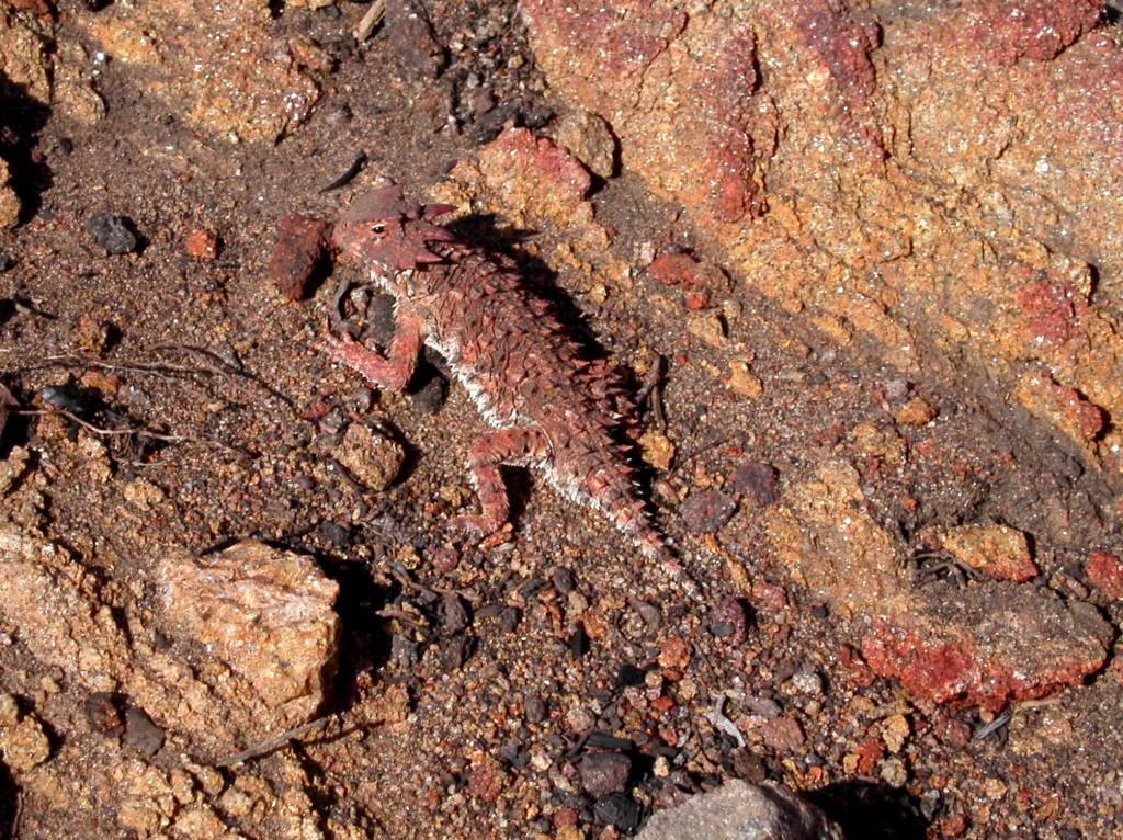
Hauser Canyon to Boulder Oaks Campground June 10, 2003
It was a June Gloom day in El Cajon when we left and beautiful, clear and 60 degrees when we arrived at the trailhead. Bill Redman and I walked back to Hauser Canyon from Lake Morena so he could get the steps that he missed because of the emergency pickup. It is an easy trail over the hills to the canyon. We took some pictures of trees he thinks are Junipers. The trip down and back was easier for me because of the lower temperatures. We walked to the helicopters landing spot. I don’t like retracing steps but it had to be done. It may be nuts but we have to do it. I want to say I walked the whole trail someday and so does Bill. We saw the most amazing bug with three fuzzy almost fluorescent segments about 6 tenths of an inch long with a narrow black band between the second and third segment (the thorax and abdomen). It seems to have six legs and is impossible to photography because it won’t stop moving. Of course we can’t figure it out now or find a photo on the internet. The god awful tarantula hawk was flying around. We found a good sized rattler on the trail on the way back and they scare Bill even more than it does me. We threw rocks to wake it out of its stupor in the sun and it finally noisily left the trail. I will never be able to forget that sound. We saw and photographed a horned lizard (horny toad). I haven’t seen any of these since I was a kid. We saw a yellow poppy that we have seen before and than an exact replica in purple. Indian paintbrush lined the trail and wild mustard. We heard the train whistle from Campo. That was a surprise. Maybe the train nuts are at work on a Tuesday. The agaves and yucca were in bloom. It took us almost four hours to get back to Lake Morena. We took a lunch break in the cool shade of an oak. A golden eagle with a four to five foot wingspan raced by chased or followed by ravens. The trail follows the lake and then goes northeast. It is an old jeep trail. I found out what chemise is. It is prettier that manzanita. We went up gently and then into a small beautiful valley with oaks and a dry creek. The trail goes up follows a ridge and then goes down to Buckman Springs road. There is a warning poster about not running over a special frog when you are driving on the road at sixty miles an hour. Good luck. We passed under the cottonwood bridge and saw swallows and their mud nests. Bill says now he knows what happened to the ones at San Juan Capistrano. The trail runs about 100 yards east of Buckman springs road for quite a while on the old road then turns right to Boulder Oaks campground. It was a great day.
PCT Journal
Campo to Lake Morena -May 27th, 2003
Brendan brought Bill Redman, Gary Good and I to the monument. Gary is an old friend of Bills from Wavetek days. We took some pictures and touched the Mexican side. Brendan show no remorse about not joining us and sped away to go to school. We began about 7:15am and headed north. The trail is easy to follow and we never had a problem finding it. The rains provide some pretty flowers and growth. I tried reading the instructions from the PCT book while walking but that is an accident waiting to happen. I never can imagine the trail exactly until I get on it. I studied the maps and instructions but am always a little surprised by the actual thing. I suppose that will change with experience and time. We passed Highway 94 and saw some discarded clothes and water bottles. There is no question that at this point in the trail some illegals use it. Bill didn’t want to camp in this area, only day trips. I think he is right to be a little cautious. Soon we crossed the old railroad tracks and saw a giant PCT sign. I don’t imagine many people see it. The railroad is supposedly being rebuilt and will be in use in the future. You can see the 94 for quite a while. Hiking is not an efficient way to cover miles but a pleasant one. We ran into “Solo” from New York tall guy about 35 with a big pack. He was finishing the PCT today. 27 days out of Tehachapi on his third and final summer on the trail. He must have been up early to finish. We found his campsite quite a way up the trail. It was exciting and motivational to see him. He warned us of a rattler over the next hill. He had seen 10 since Tehachapi and said they had become a nuisance. We didn’t see or hear the snake. It got plenty hot, about 100 degrees, and we took a long break under a tree. I get headaches in the heat and a stop ends it. At about 10 miles we stopped for an hour and lunch. I am starting to understand Topographic maps and for the first time can guess landmarks and our general position. This is an easy trail to follow but it is great to know where you are at. Gary didn’t seem to want to get up after the long break and we should have known something was wrong with him but I figured he was just tired. We got to a long trail overlooking Hauser Canyon. It is a long switchback to the bottom and then you go up a zigzag on the other side. We saw signs in Spanish that said, “Don’t expose your life to the elements. It is not worth it.” Gary stopped several times and finally Bill asked him about his symptoms. He was nauseous and weak. He would rest, throw up, and walk a bit more. Hauser Creek was dry. We met “Dr. G” Bill Gager a retired math and science teacher from South Carolina. He was spending 20 days on the trail and had a space blanket covered umbrella ala Ray Jardine. Supposedly it keeps you much cooler. He said “you have to do this while you are healthy.” At the bottom of Hauser Creek Gary got up to go first saying “I will go ahead.” He moved at a snails pace and we would walk ahead and wait. About a third of the way up that side he quit and lay down for good. Bill went back to him and I finally did too. Bill said “he can’t go on and needs to be taken out.” We agreed that with the cell phone I would walk up to a place where I could call in the cavalry. I tried about 10 times on the way up and kept getting Mexican Cell service. 45 heart pounding minutes later I found a spot in view of the Lake and got search and rescue on the phone. They were terrific and it only took about 45 minutes to find them, land an Astraea helicopter at the site and take him and Bill out to Lake Morena. They had a fire truck, paramedics and forest rangers waiting. I am sure Gary was embarrassed. Bill doesn’t like to fly. He wanted to walk out and get credit for the hike. We will redo that portion even though Donna thinks that is nuts. Gary went to the hospital and Bill walked in from the other end to meet me. We were both wearing our headlamps in the dark. It was pretty funny. I heard a rattler just before I ran into him. It sounded like a sprinkler going off. Bill said “I won’t hike with anyone but you and Kristen anymore. We both felt bad about what happened but in the end it was Gary’s decision to go with us and he wasn’t in shape for it. We learned a few things. It is my responsibility to make decisions for others safety and we should have stopped him sooner. He was a guy and didn’t tell us how he was feeling until Bill asked. We should always ask direct questions. Also take more water. I was out when I arrived and lighter colored shirts for the hottest days. What a start for the PCT.
Subscribe to:
Posts (Atom)